The new atlas generation: Atlas of Switzerland – online
The main idea behind this new version of Atlas of Switzerland is to build a common platform for online atlases. We named it Atlas Platform Switzerland or APS. This framework should have the potential for combining interactive thematic cartography with online 3D atlas technology. The APS framework consists of extensible modules for spatio-temporal navigation, map visualization and information retrieval, integrated in a web application user interface. The modules will be developed gradually; at the moment we are working on the core functionality, which can afterwards be extended according to user needs.
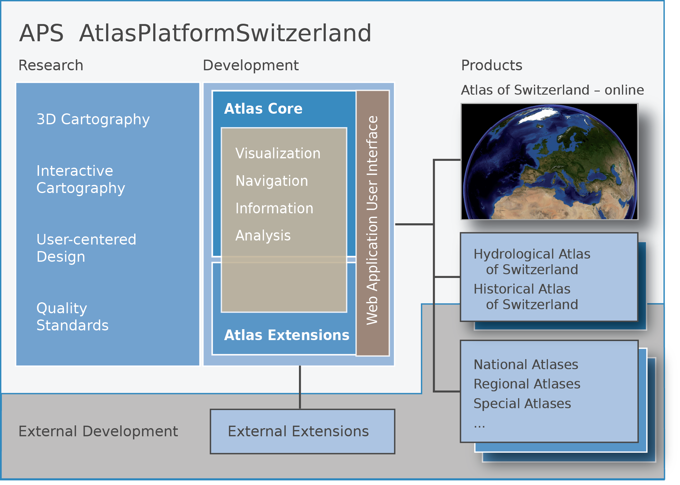
The APS core modules offer basic functionality for 3D and 2D visualization, spatial and temporal navigation, as well as query and analysis of map elements:
- General Atlas Functions – Language, Tooltips, Help, Preferences, Contact, Exit, Home, Imprint, Print map, Export map, Map services (WMS), Full Screen (switch GUI on/off)
- Spatial Navigation – Zoom (with full view), Pan, Free navigation (flight mode), Reference map (current position), Object search, Camera position, Geographic position (Coordinates, Altitude)
- Temporal Navigation – Timeframe, Timeline (Start/Stop)
- Thematic Navigation – Theme list (hierarchic organization), Active themes, Theme search
- Information Retrieval – Map element/object query (Picking), Labeling (map objects), Legend, Thematic info (including Multimedia elements and Web links)
- Map Analysis – Measuring (Distance, Area), Terrain profile
- Map Visualization – Base map manipulation (altering the map), Transparency (global or layer-specific), Extruded footprints (choropleths, 3D objects), Lighting, Sky (sun, stars)
- Map Views (Atlas modes) – 3D globe, 3D block diagram, 2D maps
- Visualization Types:
- Vector – choropleths, points (abstract, pictorial), symbols (univariate, diagrams), billboards, lines, 3D objects (only simple geometry)
- Raster – images, grids (queryable raster cells)
The above list of APS functions clearly shows that in the basic framework, the most attention is given to navigation and visualization aspects. In future, the APS core will be extensible in two ways: for internal add-ons in the context of the Atlas of Switzerland project, and also for collaboration with external atlas partners.
The most important part of the APS is the 3D visualization engine osgEarth, an OSG-based Virtual Globe. The osgEarth technology offers real-time rendering and navigation, high geodetic quality, dynamic streaming of large data sets, multi-resolution terrain representation including a level-of-detail approach (LOD), and finally the visualization of raster and vector maps. Atlas functionality is provided to the user by means of a Web-application interface.
Highlights
The Atlas of Switzerland – online will be based on an updated collection of existing map topics from former editions, e.g. geology in category Nature and Environment. In parallel, the list of existing thematic topics will be completed by new categories, e.g., History and Future. Flagship topics/maps like “Last Glacier Maximum” might be used as a means for AoS product branding.
Map of the Month
There will be a Map of the Month to draw attention on specific events, or simply to propagate “forgotten” maps that are not frequently visited.
Combination of 3D and 2D Map Views
As a main visualization principle, a map should be presentable in 2D and 3D, thus combining the advantages of orthogonal and perspective map view. 3D visualization techniques that fulfill this requirement are e.g. tubes, fences, billboards, extruded objects, floating objects and layer, or solid 3D objects. In every case, a 2D map will provide object information of the top surface or the tilted objects, whereas a 3D map may contain additional variable values on its z-axis (by means of height, color, texture).
Patterns and relations are easy to recognize
As a main visualization principle, a map should be presentable in 2D and 3D, thus combining the advantages of orthogonal and perspective map view. 3D visualization techniques that fulfill this requirement are e.g. tubes, fences, billboards, extruded objects, floating objects and layer, or solid 3D objects. In every case, a 2D map will provide object information of the top surface or the tilted objects, whereas a 3D map may contain additional variable values on its z-axis (by means of height, color, texture).
KISS: Keep it smart and simple!
The AoS interface is following the principles of User centered interface design, including usefulness and usability testing. Atlas functionality should be kept at minimum level, and only augmented upon user request. Hence, the GUI design will be simple but smart: A minimum set of GUI elements should be placed on the screen. The map window should be the most important GUI element, and thus keep the biggest part of the screen. Responsive design is a must for self-adapting the AoS to different screen sizes. And last but not least, the AoS GUI will be graphically designed by professionals.